spectors_logo_bh_rb_v001spectors_logo_bh_rb_v001
INTERREG_EU_Logo_V002INTERREG_EU_Logo_V002
  • HOME
  • ACTIVITIES
  • ABOUT
  • TEAM
  • CONTACT
  • PRODUCTS
YouTube
Twitter

Object Recognition

Due to increase quality in the images provided by UAVs, research is moving towards find automatized ways to pre-process them and classify objects, count them, assess whether it is likely a crop is healthy or not, etc.

Algorithms for Object Based Image Analysis (OBIA), machine vision and machine learning are the way to go.

BLOG on Category “Object Recognition”

Civil Drone Technology in Nature Monitoring

2020-05-15SPECTORSAll, Object Recognition
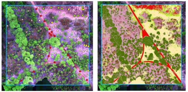
Bureau Waardenburg (BUWA; https://www.buwa.nl) is a SPECTORS partner who specializes in the fields of ecology, environment and landscape design, commissioned by both governments and private companies. Inside the SPECTORS project, BUWA focuses on developing products for monitoring nature and water.   Identifying Caltha palustris from aerial images using deep learning Unmanned aerial vehicles (UAVs) have...
Read More

Linking scientific developments and industrial applications

2020-04-21SPECTORSAll, Big Data, Drone Positioning, Hyperspectral, Object Recognition, Precision Agriculture, Surveying and Inspection
Hochschule Rhein-Waal (HSRW; https://www.hochschule-rhein-waal.de/en) is one of the scientific partners within the SPECTORS project and is responsible to link scientific development and industrial use between partners. Through close collaboration with different partners within the SPECTORS project, HSRW had made progress in different applications.   On-premise cluster environment for remote sensing applications Knowing the importance of...
Read More

Remote Sensing in Nature Conservation

2020-01-14SPECTORSAll, Fieldwork, Object Recognition
The Naturschutzzentrum im Kreis Kleve e.V. (NZ-Kleve; www.nz-kleve.de) is one of the SPECTORS partners, responsible for nature preservation in many protected areas within the district of Kleve since 1993. Within the SPECTORS project, NZ-Kleve focuses on exploring new methods in nature conservation using remote sensing and airborne technologies.   Water level monitoring The UAV system makes...
Read More

From drone images to vegetation classes

2019-07-26SPECTORSAll, Object Recognition

KWR Water Research Institute (http://www.kwrwater.nl) is one of the SPECTORS partners that focuses on creating high quality vegetation maps using images of Remotely Piloted Aircraft Systems (RPAS, commonly known as “drones”). Object recognition and vegetation mapping KWR developed an object recognition workflow to convert Remote sensing  images (by RPAS or satellites) into a number of…

Read More
Next Project
Hyperspectral
Hyperspectral
Physical Interactions with Drones